Please show your support of Waihekepedia by adding a link to us from your web site. Waihekepedia T Shirts now available at the Ostend Market
Difference between revisions of "Orapiu Wharf"
Jump to navigation
Jump to search
Hackademic (talk | contribs) |
m (Text replacement - "\<googlemap(.*)lat="(.*)" lon="(.*)" zoom="(.*)" width="(.*)" height="(.*)"\>(.*)\<.googlemap\>" to "{{map|lat=$2|lon=$3|zoom=$4|width=$5|height=$6|title=$7}}") |
||
| Line 4: | Line 4: | ||
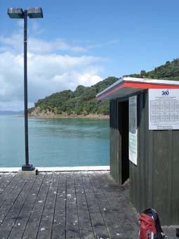
[[Image:Orapiu Wharf.jpg|frame|right|Orapiu Wharf]] | [[Image:Orapiu Wharf.jpg|frame|right|Orapiu Wharf]] | ||
[http://www.openstreetmap.com/?lat=-36.84325&lon=175.15203&zoom=16 OpenStreetMap location of Orapiu Wharf] | [http://www.openstreetmap.com/?lat=-36.84325&lon=175.15203&zoom=16 OpenStreetMap location of Orapiu Wharf] | ||
| − | + | {{map|lat=-36.84325|lon=175.15203|zoom=14|width=300|height=200|title=Orapiu Wharf on Google Maps}} | |
[[Category:Maps]] | [[Category:Maps]] | ||
Latest revision as of 10:11, 7 October 2014
Orapiu Wharf is located at the far South East End of Waiheke Island. Ferries have at different times run between Coromandel and Auckland, stopping at Orapiu Wharf, a few times per week. Currently (2009) there is no service.

Orapiu Wharf
OpenStreetMap location of Orapiu Wharf