Please show your support of Waihekepedia by adding a link to us from your web site. Waihekepedia T Shirts now available at the Ostend Market
Difference between revisions of "Rangihoua Creek"
Jump to navigation
Jump to search
| Line 18: | Line 18: | ||
| − | <gmap lat="-36.805024" long="175.060272" zoom=" | + | <gmap lat="-36.805024" long="175.060272" zoom="1" width="600" height="480">Map Title</gmap> |
[[Category:The environment]] | [[Category:The environment]] | ||
Revision as of 10:39, 5 October 2007

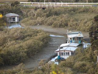
Rangihoua Creek flows into an inlet of Putiki Bay.It is home to a community of Houseboats. Other houseboats can be found at the eastern end of Putiki Bay adjacent to the intersection of The Causeway and Wharf Rd.
<gmap lat="-36.805024" long="175.060272" zoom="1" width="600" height="480">Map Title</gmap>