Please show your support of Waihekepedia by adding a link to us from your web site. Waihekepedia T Shirts now available at the Ostend Market
Difference between revisions of "Waiheke Island"
Hackademic (talk | contribs) (adding cat) |
Hackademic (talk | contribs) |
||
| Line 1: | Line 1: | ||
| − | Waiheke Island is situated in the Hauraki Gulf | + | [[Image:island.jpg|frame|left|Waiheke Island]]Waiheke Island is situated in the Hauraki Gulf. |
| − | + | Latitude (DMS): 36° 47' 60 S | |
| + | Longitude (DMS): 175° 5' 60 E | ||
| − | Waiheke Island has a permanent population of around 8000 residents. | + | Only 17km from central [[Auckland]], Waiheke is an easy 35-40 minute ferry ride from the city's downtown piers. It is the second largest island in the Hauraki Gulf, after [[Great Barrier Island]]. Its proximity to Auckland means it has become New Zealand third most populated island. |
| + | |||
| + | The climate is often said to be generally warmer than Auckland with less humidity and rain, and more sunshine hours. There is no real evidence of this. | ||
| + | |||
| + | Waiheke Island has a permanent population of around 8000 residents. Visitors at the peak of summer are said to bring numbers on the island up to 25,000 to 30,000 but, again, there is no real proof. | ||
| + | |||
| + | For many years considered something of a refuge for anyone in need of refuge, Waiheke has these days become an eclectic community, made of all social strata. Luxury homes pepper the hills and coastline, while the valleys are still full of modest homes and baches. | ||
Tangata whenua for the island is [[Ngati Paoa]], one of the tribes in the Hauraki Confederation. The island's marae, however, is [[Piritahi Marae]], a pan-cultural centre established on a city council reserve at the western end of Blackpool. Its long-term chairman and prominent kaumatua is [[Kato Kauwhata]]. | Tangata whenua for the island is [[Ngati Paoa]], one of the tribes in the Hauraki Confederation. The island's marae, however, is [[Piritahi Marae]], a pan-cultural centre established on a city council reserve at the western end of Blackpool. Its long-term chairman and prominent kaumatua is [[Kato Kauwhata]]. | ||
| + | |||
| + | ===History=== | ||
[[Category:Islands]] | [[Category:Islands]] | ||
Revision as of 09:10, 24 October 2007
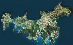
Waiheke Island is situated in the Hauraki Gulf.
Latitude (DMS): 36° 47' 60 S Longitude (DMS): 175° 5' 60 E
Only 17km from central Auckland, Waiheke is an easy 35-40 minute ferry ride from the city's downtown piers. It is the second largest island in the Hauraki Gulf, after Great Barrier Island. Its proximity to Auckland means it has become New Zealand third most populated island.
The climate is often said to be generally warmer than Auckland with less humidity and rain, and more sunshine hours. There is no real evidence of this.
Waiheke Island has a permanent population of around 8000 residents. Visitors at the peak of summer are said to bring numbers on the island up to 25,000 to 30,000 but, again, there is no real proof.
For many years considered something of a refuge for anyone in need of refuge, Waiheke has these days become an eclectic community, made of all social strata. Luxury homes pepper the hills and coastline, while the valleys are still full of modest homes and baches.
Tangata whenua for the island is Ngati Paoa, one of the tribes in the Hauraki Confederation. The island's marae, however, is Piritahi Marae, a pan-cultural centre established on a city council reserve at the western end of Blackpool. Its long-term chairman and prominent kaumatua is Kato Kauwhata.
