Please show your support of Waihekepedia by adding a link to us from your web site. Waihekepedia T Shirts now available at the Ostend Market
Difference between revisions of "Cactus Bay"
Jump to navigation
Jump to search
| Line 6: | Line 6: | ||
|- | |- | ||
| Google Maps location of Cactus Bay | | Google Maps location of Cactus Bay | ||
| − | < | + | <googlemap lat="-36.767" lon="175.13" zoom="15" width="400" height="300" type="hybrid">Map Title</googlemap> |
|} | |} | ||
[[Category:Beaches]] | [[Category:Beaches]] | ||
[[Category:Maps]] | [[Category:Maps]] | ||
Revision as of 01:33, 19 November 2008
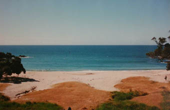
For decades Cactus Bay, east of Onetangi on the northern coast of the island, was popular with locals as a secluded getaway. However, after the 20-year dispute over the loop road was settled, landowner John Spencer firmly rejected the idea of public access to the beach and now the only way to get there is by sea.
| Google Maps location of Cactus Bay
<googlemap lat="-36.767" lon="175.13" zoom="15" width="400" height="300" type="hybrid">Map Title</googlemap> |
