Please show your support of Waihekepedia by adding a link to us from your web site. Waihekepedia T Shirts now available at the Ostend Market
Difference between revisions of "Waiheke Channel"
Jump to navigation
Jump to search
Hackademic (talk | contribs) |
Hackademic (talk | contribs) |
||
| Line 1: | Line 1: | ||
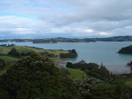
[[Image:waiheke channel.jpg|left|frame|Waiheke Channel, viewed from above Orapiu and looking over to Ponui]]The Waiheke Channel is generally considered to be the body of water to the east of [[Waiheke Island]], between Waiheke to the west and [[Pakatoa Island]], [[Rotoroa Island]] and [[Ponui Island]] to the east. | [[Image:waiheke channel.jpg|left|frame|Waiheke Channel, viewed from above Orapiu and looking over to Ponui]]The Waiheke Channel is generally considered to be the body of water to the east of [[Waiheke Island]], between Waiheke to the west and [[Pakatoa Island]], [[Rotoroa Island]] and [[Ponui Island]] to the east. | ||
| + | Sunday Rock is a marked navigation hazard towards the south end of the channel. | ||
[[Category:Islands]] | [[Category:Islands]] | ||
Revision as of 07:22, 4 December 2007

Waiheke Channel, viewed from above Orapiu and looking over to Ponui
The Waiheke Channel is generally considered to be the body of water to the east of Waiheke Island, between Waiheke to the west and Pakatoa Island, Rotoroa Island and Ponui Island to the east.
Sunday Rock is a marked navigation hazard towards the south end of the channel.